
![]() t has been said that every road his its story, and that the longer and older the road, the more important the story. The Conestoga Pike or "Old Conestoga Road", as it was known during the colonial period, is such a road. Land surveys as early as 1684 indicate that it was part of the original Allegheny Path, the "one Inden road" running near "ye ffalls of Shoolkill." From Philadelphia on what is now Allegheny Avenue, the path burrowed through the wilderness along the present-day Montgomery Avenue to Haverford, Paoli, and then westward to Morgantown and the Allegheny Valley.
t has been said that every road his its story, and that the longer and older the road, the more important the story. The Conestoga Pike or "Old Conestoga Road", as it was known during the colonial period, is such a road. Land surveys as early as 1684 indicate that it was part of the original Allegheny Path, the "one Inden road" running near "ye ffalls of Shoolkill." From Philadelphia on what is now Allegheny Avenue, the path burrowed through the wilderness along the present-day Montgomery Avenue to Haverford, Paoli, and then westward to Morgantown and the Allegheny Valley.
Through narrow winding, the path during the early days of settlement was not as inaccessible as one might imagine. The thick canopies of the trees and the Indians' frequent grooming of the forest floor for kindling made the environs almost park-like. Certainly by the 1700's, it was a well-defined path; the Susquehannocks and other tribes were at that time actively trading with the licensed Indian traders in Philadelphia.
The early traveler through these parts most likely came by horseback to hunt or trap. The long stretches of solitude and the deep woods inhabited by wild turkeys, wolves, bears, and deer were broken up by an occasional Indian settlement. The Lenni-Lenape or Delaware Indians found here were a peaceful, agrarian people who lived in informally arranged villages of one-family, peaked-roofed bark houses. On their own journeys, the Indians were said to be "never in haste, for they are everywhere at home." The eighteenth century white trader was consequently advised that he "be content not to hasten but accommodate himself to their movements."
The acquisition of horses by the Indians as well as the increase of settlers undoubtedly altered the traffic pattern on the trail. The early settlers were called "purchasers and adventurers", and often obtained land through William Penn grants without being given specific boundaries or locations other than "in Penn's Woods." They lived in caves dug into the embankments of the rolling, wooded countryside and blazed trails through the wilderness by cutting chips in the sides of trees. Some of the caves were occupied for years by a succession of settlers while they constructed log dwellings. Crops were planted between the charred trunks. Blackbirds and crows were a particular threat and prompted Legislation to pass an act granting settlers a bounty of 3 pence a piece for one crow's head or those of one dozen blackbirds.
 However, a more urgent item on the settlers' agenda was the building of new roads and the improvement of existing Indian paths. In 1680 a special court under Penn's government was established to appoint road supervisors and "fence-viewers" for each township. This responsibility was later designated to the municipalities themselves, but the goals remained the same. Roads were to be built to accommodate the span of a wagon, at least ten feet in width, and bridges erected where necessary. Cowpaths were also used at this time since cows, allowed to roam free, always found the best way home.
The inhabitants of the original Welsh Tract, a 40,000 acre area extending from Merion to Downingtown, are believe to have improved the eastern section of the Allegheny Path, near Philadelphia. In 1718 a road petition was granted for the section running through Charlestown Township and the Pikelands, where the English and Germans subsequently settled. During the height of the French and Indian War in 1755, the boat-shaped, slate blue Conestoga wagon made its appearance. As it was often pulled by four to six teams of draught horses of the Conestoga breed, the wagon eventually acquired the same name. The Conestoga Wagon, which in turn gave the road its name, was especially designed for the region's mountainous terrain. It could hold up to six tons of cargo, and in fact, was first used by General Braddock to carry supplies for his journey to the Continental Army during the Revolutionary War. Renamed to "Prairie Schooner", it was instrumental in the success of the great Westward Movement during the 1820's.
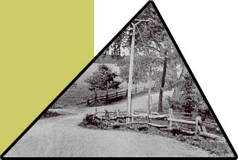
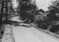
The Conestoga Pike at this time was the shortest route from Philadelphia to Harrisburg. As a turnpike (incorporated in 1811), it was maintained to twenty-feet in width and was well suited to wagon traffic. It served as an alternate route westward since it connected two well-traveled thoroughfares, the Lancaster Pike and Ridge Road (Route 23). Following its winding, hilly course, the Conestoga Wagon must have impressed local residents with its great white-peaked canvas top, creaking wheels, and jingling horse collars.
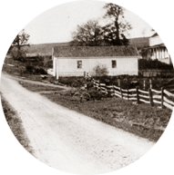
For a short period in Conestoga's long history, toll gates were the traveler's main obstacle. Like many old roads, the Conestoga was once a privately owned turnpike built for profit. It was first proposed in 1809 by Col. Thomas Bull, whose mansion property adjoined the Conestoga. Prior to and after his heroic service in the Revolutionary War, he was the manager of Warwick Furnace in Warwick Township. He also served for many years in the State House of Representatives. With several other prominent Conestoga residents such as John Malin, Michael Gunkle, Isaiah Kirk as well as "Mr. Bowen of the Ship Inn" in Exton, Bull formed the Little Conestoga Turnpike Company. They named the road "The Little Conestoga" to avoid confusion over Pennsylvania's first turnpike, the Lancaster Pike or "The Great Conestoga." The new turnpike was to run from the junction of the Lancaster Pike to the base of the Welsh Mountains, two miles east of Morgantown. At this point, the road would be managed by another company to Blue Ball, and so on to the Lancaster via New Holland. Shares of stock, sold at $5 apiece, served to finance the Conestoga's reconstruction and transformed it from a modest dirt lane into a wide, cobblestone turnpike. Its pavement was chinked with packed dirt and small stones which served as the "winter road." With the addition of two twenty-foot wide dirt "summer roads" on either side of this paved center, the turnpike measured sixty-feet in width. It was completed in 1819 at the cost of $7,516 per mile.
Subsequent road repairs and maintenance were financed by fares collected at toll houses spaced between seven and ten miles apart. The tollkeepers mathematical ability was challenged daily as tolls varied in accordance to how much damage a certain vehicle or animal inflicted on the road. A mule was considered equal to a horse, for example, while two oxen were the same as one horse.
 While other turnpikes had a period of success, the Conestoga (the fourth turnpike established in Pennsylvania) never proved profitable to its shareholders. Other highways less hilly and more populated with taverns or hostelries handled much of the east-west traffic. Also, the Conestoga apparently had its share of "shun-pike" activity. That is numerous side roads and widely-spaced toll gates made it easy for travelers to avoid the "pike" and toll collector. After a lapse of thirty years, the Little Conestoga Turnpike Company was disbanded and the toll gates taken down. Although it failed as a business venture, the Conestoga Turnpike helped unite the residents, it increased property values, and created local businesses. And because it was not used as frequently as other roads, much of its rural beauty and that of the surrounding countryside has been preserved to the present-day.
Welcome | History of the House | The Restoration | Blue Prints
About the Road | Maps | Chester County Resources